
NISAR 2024
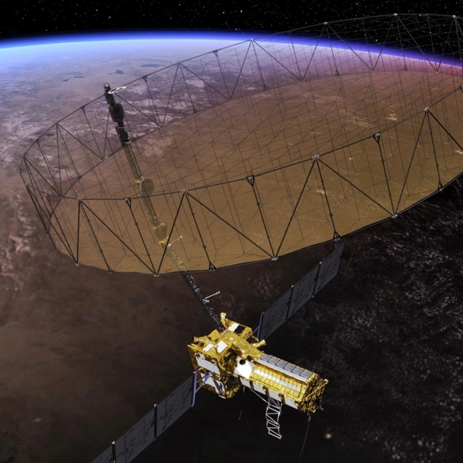
The NASA-ISRO Synthetic Aperture Radar (NISAR) is a collaborative Earth-observing satellite mission between NASA (National Aeronautics and Space Administration) and ISRO (Indian Space Research Organization). NISAR is designed to study and monitor Earth’s surface deformation, ecosystem disturbances, and changes in ice masses.
Objectives of the NISAR satellite mission
- SAR Technology – NISAR is equipped with a Synthetic Aperture Radar (SAR) instrument, which allows it to capture high-resolution radar images of the Earth’s surface. SAR technology is particularly useful for observing changes on the Earth’s surface, such as ground subsidence, earthquakes, volcanic eruptions, and glacier movements.
- Dual-Frequency Radar – NISAR features a dual-frequency radar system, which means it can operate in both L-band (NASA’s part of the mission) and S-band (ISRO’s part of the mission). This dual-frequency capability provides complementary data for a wide range of Earth science applications.
- Global Coverage – NISAR will provide global coverage, allowing it to monitor various regions of the world. It is expected to capture data on a regular basis, enabling scientists to track changes in land and ice masses over time.
- Earth Science Applications – NISAR data will be used for a variety of Earth science applications, including monitoring the ice sheet and glacier dynamics, studying tectonic plate movements, tracking land subsidence, and understanding the dynamics of forests and ecosystems.
- Natural Disaster Monitoring – One of the important applications of NISAR is to improve our ability to monitor and respond to natural disasters such as earthquakes, volcanic eruptions, and landslides. The satellite can provide valuable data for disaster management and response.
- Climate Research – NISAR data will contribute to climate research by helping scientists understand the role of ice sheets and glaciers in sea-level rise and by monitoring changes in vegetation and forests, which play a crucial role in the Earth’s carbon cycle.
NISAR using Machine Learning Algorithms
Machine learning algorithms can be applied to this data to extract valuable information, identify patterns, and improve the analysis of various Earth science phenomena. Here are some ways in which machine learning algorithms can be utilized in conjunction with NISAR data:
Land Subsidence Monitoring
Machine learning can help detect and monitor land subsidence, which is a crucial issue in areas prone to sinking due to various factors, including groundwater extraction and geological processes. Algorithms can process NISAR SAR data to identify areas experiencing subsidence and predict future subsidence risks.
Earthquake Prediction and Detection
Machine learning algorithms can analyze NISAR data to identify ground deformation patterns associated with potential seismic activity. By detecting changes in the Earth’s surface, these algorithms may contribute to early earthquake prediction and monitoring.
Glacier and Ice Sheet Monitoring
NISAR data can be used to track changes in glaciers and ice sheets. Machine learning can automate the process of detecting glacier flow, ice sheet thickness, and changes in ice mass, providing valuable insights into climate change and sea-level rise.
Forest and Vegetation Analysis
Machine learning algorithms can analyze NISAR data to monitor forest and vegetation health. They can assess biomass, deforestation, and land cover changes, aiding in ecosystem conservation and carbon cycle studies.
Natural Disaster Response
Machine learning can assist in the rapid assessment of natural disasters, such as floods, landslides, and volcanic eruptions, by analyzing NISAR data for real-time monitoring and damage assessment.
Crop Health and Agriculture
NISAR data can be used to monitor agricultural land. Machine learning algorithms can analyze crop health, predict yields, and identify areas at risk of drought or other environmental stressors, aiding in food security efforts.
Data Fusion and Integration
Machine learning techniques can be employed to combine NISAR data with other Earth observation data sources, such as optical imagery or meteorological data. This fusion enhances the accuracy and scope of analysis.
Image Denoising and Enhancement
SAR data often contain noise and artifacts. Machine learning can be used for image denoising and enhancement, improving the quality of NISAR images and facilitating more accurate analysis.
Pattern Recognition
Machine learning can assist in recognizing specific patterns in NISAR data, such as identifying urban growth, monitoring infrastructure development, or tracking the movement of icebergs.
To implement machine learning algorithms effectively with NISAR data, a multidisciplinary approach involving remote sensing experts, data scientists, and domain specialists is often required. These experts work together to develop and fine-tune models, validate results, and translate findings into actionable insights for various Earth science applications. Additionally, access to large-scale computing resources may be necessary for processing and analyzing the vast amount of data collected by the NISAR satellite.
Working of NISAR
Synthetic aperture radar, a complex information-processing method, is used by NISAR to provide incredibly high-resolution images. NISAR can collect data day and night in any weather because radar can see through clouds and darkness. The imaging swath of the instrument, or the length of the data strip acquired along the length of the orbit track, is greater than 150 miles (240 km), allowing it to survey the entire Earth every 12 days. The radar scans will enable users to track alterations in croplands and danger areas, as well as to keep an eye on ongoing events like volcanic eruptions. The photos will be comprehensive enough to measure regional trends and detailed enough to show local changes. The data collected over the course of the mission’s many years will improve our comprehension of the factors that contribute to land surface changes and their effects, enhancing our capacity to manage resources and adapt to a changing world.
In Conclusion, NISAR will be launched into a near-polar orbit in 2024 from the Satish Dhawan Space Centre in Sriharikota, India. NASA mandates a minimum of three years of L-band radar operations for global science, while ISRO mandates five years of S-band radar operations over predetermined target areas in India and the Southern Ocean.
Source
- https://nisar.jpl.nasa.gov/
- https://www.isro.gov.in/NISARSatellite.html
- https://www.isro.gov.in/NISARSatellite.html#:~:text=NISAR%20will%20map%20the %20entire,%2C%20tsunamis%2C%20volcanoes%20and%20landslides.
- https://www.javatpoint.com/machine-learning-algorithms
- https://www.isro.gov.in/nisarmission_nasa.html